
Lake Lanier water levels and boating: how dam releases change plans
Stand on Dock Zk at Aqualand Marina in late autumn and you can read the lake off the pilings: a wet band of concrete above the waterline means Buford Dam has been releasing. After 20-plus years sailing out of Flowery Branch, that is the short lesson on Lake Lanier water levels and boating. The lake drops a few feet, the shoreline moves inward, and the sail still happens somewhere else on the water.
Why Lake Lanier water levels and boating plans are linked
At full pool, 1,071 feet above sea level, Lake Lanier covers roughly 38,000 acres, and that elevation is not a natural condition. The U.S. Army Corps of Engineers describes the lake as a Corps-managed reservoir created by Buford Dam, which means the surface is set by rainfall and by release decisions made downstream. That elevation decides what is sailable and what is not.
Every sail I run leaves from Dock Zk at Aqualand Marina near Flowery Branch, so Lake Lanier water levels and boating logistics show up first at the dock itself: how far down the gangway tilts, how much freeboard sits between the finger pier and the deck, and whether the fairway out of the slip has its usual depth. The U.S. Army Corps of Engineers, which manages Buford Dam and publishes the reservoir daily elevation readings, is the only authority worth trusting for that number.
Scale is the reason small elevation changes matter here. Spread a one-foot drop across those 38,000 acres and the 692 miles of shoreline tracked by the Lake Lanier Association, the lake's volunteer shoreline and water quality group, and you get hundreds of newly shallow acres at the edges, mostly in the backs of coves where the bottom rises gently. The main channel between Browns Bridge and the dam keeps plenty of depth for a keelboat. The shallow margins are where plans change.
How Buford Dam operations change Lake Lanier water levels and boating conditions
Buford Dam releases can pull the lake down roughly 20 feet between a full pool of 1,071 feet and the December 2007 drought low of about 1,051 feet, moving water for flood risk reduction, hydropower, water supply, and downstream flow on the Chattahoochee. On the lake, that fall shows up over weeks, not hours, which is what makes it plannable.
Rain is the other half of the equation. A wet spring can hold Lanier at full pool, while a dry fall pulls it down steadily, and the U.S. Army Corps of Engineers Mobile District water management office publishes the daily reading that tracks the difference. In September 2023, the gauge read about seven feet under full pool after a dry summer, and a sunset charter booked into Shoal Creek had to move to open water off Old Federal instead, because the cove entrance guests had sailed into every August for years ran too shallow for the keel that week. Across a season, Lake Lanier water levels and boating access can look like two different lakes.
The two readings above bracket what the Corps has recorded on this reservoir. Wind and storms move faster than water levels, so I read the National Weather Service Peachtree City forecast office every morning alongside the lake level page, the same routine described in our guide to Lake Lanier sailing weather.
Changing shorelines, underwater hazards, and Lake Lanier water levels and boating safety
Five feet of elevation can be the difference between eight feet of clearance and three, which is enough to expose hazards that were comfortably deep in June: rock shoals off points, old stumps in the backs of coves, roadbeds and foundations from the valley flooded in the 1950s. None of it is new. The water simply stops hiding it.
Georgia hazard markers and buoys stay where they are, which means a buoy that sat in eight feet of water can sit in four. The Georgia Department of Natural Resources Wildlife Resources Division, which enforces state boating rules, and the U.S. Coast Guard recreational boating safety program both treat local knowledge of the waterway as the operator responsibility. On a keelboat with a fixed draft, Lake Lanier water levels and boating decisions are mostly about staying in water I have personally sounded.
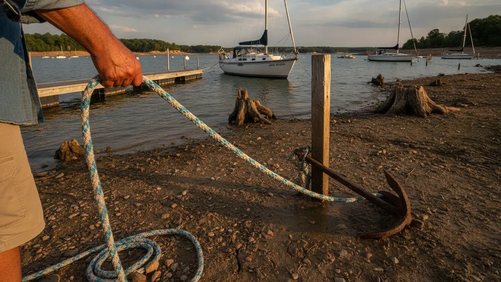
Guests notice the shoreline before they notice depth. Red clay banks widen, docks sit lower against their ramps, and sandbars appear where there was open water in spring. It changes the photographs more than it changes the sailing. If you want the landmark version of the route, our post on Lake Lanier sailing routes covers what you see from the boat.
Which official sources to check before a scheduled sail
Three sources answer nearly every question about Lake Lanier water levels and boating before a charter: the Corps publishes the daily reading against the 1,071-foot full pool mark, the National Weather Service tracks wind and storms, and the Lake Lanier Association posts shoreline and water quality notices. Check them the morning of the sail, not the week before.
NOAA, the parent agency of the Weather Service, carries the marine and hydrology products behind those forecasts, and American Sailing, the national sailing instruction body, publishes seamanship material on reading charted depths. For a plain reading of what the reservoir is and how it was built, our own Lake Lanier facts for sailors covers the history.
Here is what each source actually gives you.
How I adapt routes when Lake Lanier water levels and boating conditions shift
By moving the sail, not canceling it: a drop of five feet or more pushes me toward the main channel and the deeper water south of Browns Bridge, while a full pool at 1,071 feet opens up cove anchorages and the shallower arms. The wind matters far more than the elevation on any given afternoon.
Ramp and marina access is usually the first real constraint, and it affects guests arriving by car up I-985 more than it affects the boat. Parking and dock access at Aqualand stay workable through normal seasonal swings. Storms are the actual reason I move a date, which I wrote about in our guide to Lake Lanier thunderstorm safety. Low water reshapes Lake Lanier water levels and boating routes; lightning cancels them.
| Level against full pool | What changes on the water | How the sail adapts |
|---|---|---|
| At or near full pool (1,071 ft) | Coves and arms carry normal depth; docks sit high on their ramps | Full range of routes, including shallower coves |
| Two to four feet down | Cove entrances shoal; gangways steepen at the marina | No change to the sail; slight trim of the route near points |
| Five to ten feet down | Sandbars and stumps show; some public ramps get awkward | Main channel work between Browns Bridge and the dam |
| Drought lows (near 1,051 ft, December 2007) | Wide clay banks, exposed shoals, reduced ramp access | Deep water routes only; anchoring spots move |
Season matters more than any single reading, which is why our best time to sail Lake Lanier guide starts with months rather than feet.
Frequently asked questions
Will my sailing charter be canceled if Lake Lanier is low?
Almost never. A keelboat leaving Aqualand Marina needs depth in the main channel, not at the shoreline, and the open water holds that depth through normal seasonal swings. What changes is the route: fewer shallow coves, more time in the deeper middle of the lake. Planning around Lake Lanier water levels and boating conditions is ordinary pre-sail work for me. Weather is the real reason a date moves, and I check the National Weather Service forecast for north Georgia every morning before a charter. Lightning and sustained high wind cancel sails; a few feet of elevation does not.
How do I check the Lake Lanier lake level before my trip?
Go to the source that measures it. The U.S. Army Corps of Engineers Mobile District, which operates Buford Dam, publishes the reservoir elevation along with its full pool reference of 1,071 feet above sea level. Compare the current reading with that number and you know roughly how far down the lake sits. One or two feet is unremarkable. Eight or ten feet down means ramps, docks, and cove entrances all behave differently, and anyone launching their own boat should plan for it. Guests on a captained charter mostly notice it in the photographs.
Why does the Corps of Engineers release water from Buford Dam?
Lanier is a working reservoir, not a scenic pond. The U.S. Army Corps of Engineers identifies the lake as a Corps-managed reservoir created by Buford Dam, and operates it for flood risk reduction, hydropower, water supply, downstream flow on the Chattahoochee River, and recreation. Those purposes compete. In a dry year, water sent downstream comes out of a lake that rain is not refilling, so the surface falls. In a wet year, the lake can sit near full pool for months.
Is it safe to boat on Lake Lanier when the water is low?
Yes, with attention. Low water does not create hazards; it brings existing ones closer to the surface, including rock shoals off points and stumps in the backs of coves. Buoys and markers stay put while the depth under them changes, so the margin for error shrinks. US Sailing, the national governing body for the sport, teaches the same habit I use: know your draft, know the chart, and stay in water you have sounded. I learned that habit from instructor Dave Marlowe at Lanier Sailing Academy, where I earned my keelboat certification before taking the U.S. Coast Guard exam for my Master's license. On a charter, that judgment is mine to make, and it is where years of reading this one lake, not just a textbook, earns its keep.
What time of year does Lake Lanier usually sit lowest?
Late summer through winter tends to run lower than spring, because spring rain refills the reservoir while dry months and steady releases draw it back down. That is a tendency, not a schedule, and a wet autumn can hold the lake near full pool into November. Rather than rely on a rule of thumb, read the current elevation published by the Corps and the lake information resources kept by the Lake Lanier Association. For picking a month to sail, wind and air temperature matter more to your day than elevation does.
Do dam releases create current you can feel while sailing on the lake?
Not in any way that affects a sailboat on the open lake. Releases move water through the dam into the Chattahoochee below it, so the noticeable current sits downstream of Buford Dam, not on the reservoir. On the lake itself, the effect is a slow change in surface elevation measured over weeks. NOAA, the parent agency behind the hydrology and marine forecasts I use, treats wind as the driver of lake surface conditions, and that matches 20-plus years of sailing here: chop on Lanier comes from wind and powerboat wakes.